Drone Photography for REO and Investment Properties: What California Asset Managers Need to Know
When a bank, investor, or asset manager needs to assess a property quickly and accurately, time and information are everything. Traditional ground-level inspections have long been the standard, but they come with real limitations — missed roof damage, obscured lot boundaries, inaccessible terrain, and incomplete documentation that can lead to costly oversights. Drone photography is changing that equation entirely.
At 3LE Property Preservation & Valuation Services, based in Richmond, California and serving clients throughout the state, we have integrated professional aerial drone photography into our property inspection and valuation services to give banks, investors, and property owners a decisive advantage. With over 18 years of experience in the property preservation industry, we understand what decision-makers need — and drone imaging delivers it.
Why Drone Photography Matters for Property Inspections
Aerial photography is not just about capturing impressive images. For asset managers overseeing REO portfolios, distressed properties, or large investment holdings, drone inspections provide a level of detail and documentation that directly impacts risk management, valuation accuracy, and transaction confidence.
Comprehensive Visual Documentation
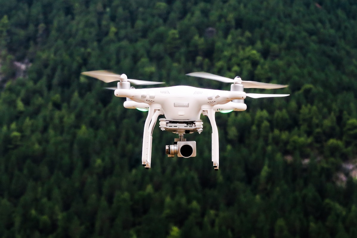
A drone can capture the full scope of a property in a single session — rooftop conditions, drainage patterns, structural anomalies, encroachments, landscaping health, and lot boundaries. This is especially valuable for California properties with complex terrain, hillside lots, large acreage, or difficult access points. Ground inspectors simply cannot see what a drone can see, and what they cannot see can become a costly liability.
Faster Turnaround for Time-Sensitive Decisions
In the REO and investment property space, speed matters. Whether you are preparing a property for sale, assessing damage after a weather event, or conducting due diligence before acquisition, drone photography dramatically reduces the time required to gather actionable visual data. A licensed drone operator can document an entire property in a fraction of the time a traditional inspection team would need, and the resulting imagery is available for review almost immediately.
Roof and Structural Assessment Without Safety Risk
Roof inspections are among the most important — and most hazardous — components of any property assessment. Sending personnel onto an unknown or deteriorating roof creates liability and safety concerns. Drone photography eliminates that risk entirely. High-resolution aerial imagery can identify missing shingles, damaged flashing, pooling water, compromised gutters, and signs of structural sagging with precision, all without a single person stepping onto the roof surface.
Drone Photography as Part of a Complete Property Preservation Strategy
At 3LE Property Preservation & Valuation Services, drone photography does not exist in isolation. It is one component of a fully integrated approach to property preservation and valuation that we have refined over 18 years of working with banks, mortgage servicers, and real estate investors across California.
Our licensed and insured team combines aerial imaging with on-the-ground property preservation services — including landscaping, handyman repairs, debris removal, and securing — to give clients a complete picture of a property's current condition and what it will take to bring it to market-ready status. When our drone imagery reveals a drainage issue or roof damage, our preservation team is already positioned to address it.
Supporting Accurate Valuations
Drone photography also plays a meaningful role in property valuation. Appraisers and asset managers rely on accurate condition data to determine fair market value, establish repair cost estimates, and make informed disposition decisions. Aerial imagery provides objective, time-stamped documentation of a property's exterior condition that supports more defensible valuations and reduces disputes during the transaction process.
For California investors managing properties in markets ranging from the Bay Area to the Central Valley to Southern California, this kind of documentation is increasingly expected — and in many cases, it is becoming a competitive standard.
Regulatory Compliance and Professional Standards
Not all drone operators are created equal. In California, commercial drone operations must comply with FAA Part 107 regulations, which require operators to hold a Remote Pilot Certificate and adhere to strict airspace, altitude, and operational guidelines. Working with an unlicensed operator — or attempting to use consumer drones for professional property documentation — creates legal exposure and produces imagery that may not hold up to scrutiny in a professional or legal context.
3LE Property Preservation & Valuation Services operates with full licensing and insurance, and our drone services meet the professional and regulatory standards that banks, servicers, and institutional investors require. When you need documentation that will stand behind a valuation, support an insurance claim, or satisfy an investor's due diligence requirements, the credentials of your service provider matter.
Who Benefits Most from Drone Property Inspections?
Drone photography for property inspections delivers the greatest value to:
- Bank asset managers overseeing REO portfolios who need fast, reliable condition assessments across multiple properties
- Real estate investors conducting pre-acquisition due diligence on properties they cannot physically visit
- Property owners seeking documentation of storm damage, encroachments, or condition changes for insurance or legal purposes
- Mortgage servicers who need to verify property condition and occupancy status efficiently
- Property managers responsible for large or geographically dispersed California assets
Serving California from Richmond and Beyond
3LE Property Preservation & Valuation Services is headquartered in Richmond, California, and we serve clients throughout the state. From the East Bay to the Inland Empire, from the Sacramento region to the Central Coast, our team brings the same licensed, professional, and detail-oriented approach to every property we inspect, preserve, and document.
If you are managing California real estate assets and you are not yet leveraging drone photography as part of your inspection and preservation workflow, you are working with incomplete information. The technology is proven, the regulatory framework is established, and the competitive advantage is real.
Ready to See Your Properties from a New Perspective?
Contact 3LE Property Preservation & Valuation Services to learn how our drone photography services can be integrated into your property inspection, preservation, or valuation process. With 18 years of experience and a full suite of licensed and insured services, we are the partner California asset managers and investors trust to protect and document their real estate holdings — from the ground up, and from the air.